The Archive has nearly 1500 maps in its collection that trace the history of Fort Collins, Larimer County, and Colorado. Some of the more frequently-referenced maps have been digitized, but the majority of the collection is not yet online and may be viewed only by visiting the Fort Collins Local History Archive.
Browse All Maps that have been Digitized
Browse maps by Geographic Location
Larimer County
Fort Collins
Colorado
Out of State
Browse maps by Decade
1860s
1870s
1880s
1890s
1900s
1910s
1920s
1930s
1940s
1950s
1960s
1970s
1980s
1990s
2000s
2010s
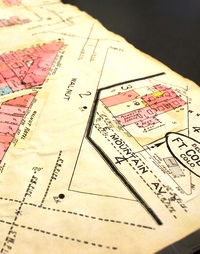
Sanborn Fire Insurance maps are large-scale plans of a city or town drawn at a scale of 50 feet to an inch. They were created to assist fire insurance companies assessing risk of various properties, and they are very helpful for historical research.
Many Colorado Sanborn have been digitized and are available for online viewing using the Library District's Sanborn Map database.
The Archive has the following paper copies of Fort Collins Sanborn maps:


Preserving the history of Fort Collins, Colorado & the Cache la Poudre region