1540-1858 | 1844-1866 | 1866-1877 | 1877-1900 | 1900-1919 | 1919-1941 | Introduction

Antoine Janis is believed to have been the first Euro-American settler in Larimer County. Janis was born in Missouri to French parents and his father freighted supplies from St. Louis to Wyoming during the heyday of the fur trade. In the waning days of that era, Janis again passed through the Cache la Poudre Valley. Charmed by its beauty, he staked out a squatter's claim west of the present site of Laporte in 1844. Janis reported that when he claimed the area, "the streams were all very high and the valley black with buffalo...and I thought the Poudre valley was the loveliest spot on earth...." Janis marked his property in the event that settlement came to the area, but did not erect a residence at that time.
One of the nation's major emigrant pathways, the Oregon Trail ran north of Larimer County, through Wyoming. During the 1840s, thousands of settlers headed west in search of new homes in Oregon, California, and Utah. The Central Overland Trail, a mail route to the coast, also went through Wyoming. Although northeastern Colorado, earlier identified as part of the "Great American Desert," was not the final object of their journey, some of the overland emigrants traveled through it before connecting with the major trails. Watrous reported that, in 1846-47, a Mormon battalion on its way to Salt Lake City entered the mountains west of Laporte.
The discovery of gold in California in 1848 led to a mass migration of prospectors to that area. In 1849, a group of Native American and Anglo-American prospectors, known variously as the Cherokee Company, the Washington County Company, or the Evans Company, set out for the California gold fields. In Colorado, they traveled from Pueblo to Fort St. Vrain on the South Platte, crossed the South Platte at the mouth of the Cache la Poudre, and subsequently entered the mountains and headed toward the Laramie Plains. The path the company took through the area, which ran west of the present site of Fort Collins, was thereafter referred to as the Cherokee Trail, although it had long been a trail for trappers and traders. Upon their return to the East, the Indian group organized another expedition to search further for gold. The second group passed through Colorado in 1850, following the Cherokee Trail as in the previous year. During the second trip, a small quantity of gold was found in Ralston Creek, near present day Arvada. This discovery influenced a prospecting group led by William Green Russell which set out for the vicinity of Ralston Creek in 1858.
Prospectors fanned out across the West in an intensive search for the metal, entering the areas they felt most likely to contain similar riches. In 1858, Russell's party found a small amount of gold at Dry Creek south of the present-day site of Denver. The news of this discovery brought forth an influx of gold-panning prospectors, many of whom had also followed the California gold rush. In 1859, when three large lode claims were made in what would later become Gilpin, Clear Creek, and Boulder Counties, people from across the United States were lured to the region by the promise of gold. Many of these gold-seekers settled in the area permanently. With the discovery of gold, a steady stream of people began to travel into Colorado, most heading toward Denver and the mining camps. Although Larimer County was not a major goal of the gold seekers, many traveled through the area on a route from Denver toward the Central Overland Trail. Some placer mining was attempted on the banks of the Cache la Poudre and several sluices were built.
It has been estimated that as many as 100,000 gold seekers set out for Colorado in 1859. Although probably less than half of that number actually reached the Pike's Peak area, the influx of prospectors, merchants, and promoters quickly transformed the fledgling settlement of Denver into an important regional center. The city also became a major destination point for emigrant and stage routes. At least nineteen emigrant guidebooks were published between 1858 and 1859, each of which advised prospective settlers on the best routes to Denver and the gold fields. Soon, the area of Larimer County served as both a pathway to the gold camps and an important agricultural supply center.
Westward-bound travelers could choose one of several major routes to Denver, all originating on the Missouri River between St. Joseph and Kansas City. The safest route was the South Platte Trail, which followed the old Oregon Trail westward along the Platte River toward Julesburg and thence ran southward to Denver following the South Platte River. Another route to the gold fields was to follow the Oregon Trail to Fort Laramie and then descend southward along the Cherokee Trail east of the mountains toward Denver. Along this route, the gold seekers traveled through the Cache la Poudre and Big Thompson river valleys. Many who tired of mining remembered these valleys as attractive places for settlement. Jared Brush, who established a ranch in the Big Thompson Valley and later became a participant in the town company which founded Fort Collins, was one such argonaut.
The gold rush was the factor which induced Antoine Janis to permanently move to the Cache la Poudre Valley from Fort Laramie in 1859. During the early days of the gold rush, Janis, like many mountain men who knew the trails and passes of the West, became a guide for prospectors heading for Pike's Peak country. The migration of large numbers of argonauts to the area motivated Janis to further legitimize his claim by building a cabin on the north side of the Cache la Poudre in 1859. Janis later remembered that, when he entered the area, about 150 lodges of Arapahos had also established themselves there. The Indians were reported by Janis to have agreed to donate to him, Elbridge Gerry, and his brother, Nicholas Janis, all the land from the foot of the mountains to the mouth of Box Elder Creek.
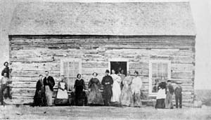
In the same year that Janis erected his cabin, a company of French Canadian families searching for a townsite came from Fort Laramie to the area which Janis had selected. They, too, recognized the significance of the movement of people into the region in terms of its future development. The company included Francis and Nicholas Janis, Antoine Le Beau, E. W. Raymond, Todd Randall, Raymond B. Goodwin, John B. Provost, Oliver Morisette, A. LeBon, and others, who created a settlement named Colona. Colona (the predecessor of Laporte) was situated on the banks of the Cache la Poudre, with the Great Plains to the east, the mountains to the west, and the emigrant trails to the north. In a burst of optimism regarding the future of the new town, the company had the site surveyed and mapped. According to Janis, fifty houses were then built for the families. These homes were, like that of Janis, constructed of logs and they formed the first community created in Larimer County. John Provost began what was one of the area's earliest commercial ventures in his log house, where he maintained a grocery and saloon. In addition, Provost initiated a second business when he built and operated a ferry for emigrants across the river.
Another early settler who established himself in the area was Rock Bush, a French-Canadian who claimed land about three miles southeast of Laporte along the north bank of the river. Bush crossed the plains with an ox team in 1857 and operated a ferry on the Green River for two years. He heard descriptions of the Cache la Poudre Valley from emigrants. In 1859, Bush built a cabin and began farming and trapping on the site where he lived for over fifty years.
Jesse M. and Frederick W. Sherwood were natives of New York who had engaged in the lumber business in Wisconsin. In 1860, the brothers took an ox team across the Plains and mined at Russell Gulch before settling in the Cache la Poudre Valley. They hauled logs from the mountains to erect a home along the river and began raising and selling horses and cattle, hay, grain, and vegetables. The Sherwood ranch was for a brief time an Overland Stage station and was well known to travelers in the region. Frederick Sherwood became a member of the first board of county commissioners and Watrous noted that to write a biography of Sherwood was to write a history of Larimer County.
Walter J. Prendergast was an Irish immigrant, who arrived in the United States in 1854 and joined the army a year later. Prendergast was sent west during a period of problems between the Mormons in Utah and the United States government. He followed the Oregon Trail to South Pass and toward Salt Lake City in 1858. Returning eastward, Prendergast and his wife crossed the Laramie Plains, descended the Cherokee Trail and decided to settle in the Big Thompson Valley, where they built a log cabin. In 1861, the Prendergasts moved to the Cache la Poudre Valley and established a ranch, cutting hay and raising vegetables for sale in the mining camps and at Fort Laramie.
Native American/Euro-American Interaction
The rush of thousands of people toward the region led to the creation of further trails and permanent settlements, as well as the killing and driving off of the area's great buffalo herds. Succeeding years were a time of crisis for the American Indian groups, as their interests came sharply into conflict with those of the new settlers.
By the mid-1800s, several successive groups of Native Americans had utilized northeastern Colorado for hunting and camping. By the 1500s, the Pawnees controlled much of the South Platte Valley north of the river, while the Jicarilla Apaches controlled the land between the South Platte and the Arkansas. During the early 1700s, incoming Comanches and their allies, the Utes, drove the Apaches south. The Utes were a mobile society of hunters who eventually occupied most of the western slope and controlled the mountain passes. During the 1800s, the Kiowa allied with the Comanches and shared their hunting grounds south of the Arkansas River after being pressed southward by incoming Arapaho and Cheyenne. One of the first reports of Arapahos and Cheyennes on the eastern plains was offered by the Long expedition in 1820. From the early 1800s, most of eastern Colorado north of the Arkansas River was occupied by the Arapahos and the Cheyennes. The Sioux also used northeastern Colorado as hunting grounds during the mid-1800s.
Fort Collins is situated where the high plains intersect the base of the mountains. This area was utilized as a hunting ground by several groups of Indians, but none had a strong hold on it. Since none of the tribes dominated in this strip of land, none offered as much resistance to Anglo settlements in this locality as in other parts of the state. Occasionally, parties of Utes would venture from their mountain lands into the region, but the land was generally viewed as a buffer zone between that Great Basin tribe and the Plains groups of Cheyenne and Arapaho. Anglos had been traveling through the area in limited numbers for years, and their presence had little influence on the lifestyle of the natives.
Watrous reported that the Cache la Poudre Valley was a favorite hunting area for the Arapaho, with beaver, buffalo, bear, deer, and antelope in plentiful supply. Their preferred camping ground during these hunting trips was along both sides of the river near present-day Laporte. These Native Americans allowed trappers and early settlers to enter the region without opposition and Watrous stated that he could find no record of "serious depredations or cruel atrocities" committed by that group upon the later entrants into the valley. As a boy, Friday, the chief of the group which utilized the valley, had been rescued while lost by mountain man Thomas Fitzpatrick. Fitzpatrick thereafter took care of Friday and sent him to school in St. Louis. Although he later returned to his family, Friday was known as a great friend of settlers in the area and was called "the Arapaho American" by Rufus Sage.
As gold seekers and immigrants moved westward in increasing numbers, the Indian tribes of northern Colorado found their traditional way of life disintegrating. New trails and settlers disrupted the Indians' territorial grounds, buffalo and other wildlife were killed or driven away, and new towns were established on land that, even by treaty, belonged to Native Americans. Beginning in the 1840s, tension increased as thousands of travelers passed through native lands along emigrant trails. After the end of the Mexican War, the United States sought to protect the routes to Oregon, California, and Santa Fe, at the same time restricting Indians to particular areas. In 1851, the Treaty of Fort Laramie followed this intent by attempting to guarantee undisturbed travel along the Oregon trail for emigrants. At the same time, the treaty confirmed the ownership of the Arapaho and Cheyenne to the plains between the Arkansas River and the North Platte River. In addition, annual provisions were to be provided the northern tribes at Fort Laramie.
By 1857, further problems arose along the trails, as emigrants were threatened by both natives and outlaws. In that year, an Army expedition was sent into the South Platte Valley to stop hostile actions against the travelers. A clash on the Solomon River in Kansas led to the defeat of the Cheyenne and cessation of these attacks for a time.
The 1860s were a time of great conflict between Colorado's Anglo and Native American populations, particularly on the plains. While the trappers and hunters had co-existed with the Native Americans, the prevailing sentiment of the new settlers was one of manifest destiny, that the Indians were doomed to vanish before the march of civilization. The Treaty of Fort Wise (1861), which offered the Arapaho and Cheyenne a reservation in eastern Colorado, was followed by numerous clashes between American Indians and the military.
By 1864, attacks had increased along the trails to the extent that Denver and the mining camps were threatened with being cut off from the rest of the country. Settlers in Larimer County were tense from reports of Indian attacks in other areas. In addition the French Canadians living in the vicinity of Laporte reportedly rode through the valley spreading false alarms about Indian threats to relieve their boredom. To calm the settlers' fears and deal with the hostility, Governor John Evans supplemented Colorado's militia with volunteers for short periods of service. At the same time, Evans requested that all Indians who considered themselves "friendly" go to established military posts. Chief Friday and his followers went to Fort Collins at this time, as did a group of Cheyenne led by Spotted Tail.
The Colorado volunteers, under the command of John Chivington, attacked a group of Cheyenne and Arapaho at Sand Creek on 29 November 1864. This battle, in which Chivington's soldiers committed numerous atrocities, angered the Cheyenne and Arapaho, who then allied themselves with the Sioux. Parties of these tribes attacked military posts and settlements in the region. In the Fort Collins vicinity, settlers and Indians had always maintained amicable relations, and some Arapahos found work on local ranches. As conflict elsewhere continued during the spring of 1865, trails closed and Colorado was in a state of emergency. The normally friendly relationship between the two groups in Larimer county was tested.
In 1867, two treaties were signed at Medicine Lodge Creek to attempt to establish peace. Under these agreements, the Cheyenne were given a reservation in Oklahoma, but retained the right to hunt in unsettled lands. The Arapaho were sent to the Wind River Reservation in Wyoming. These treaties were not solutions, as many of the Indians refused to stay on reservations. The battle of Summit Springs, in 1869, was the last conflict with the Plains Indians in Colorado. The Great Ute treaty of 1868 had already deprived the Utes of the central Rockies. Chief Friday and his group moved to the Wind River Reservation in 1869.
Settlement During the Early 1860s
By the 1860s, approximately one hundred settlers had already established themselves in the Cache la Poudre Valley. Many of the settlers had passed through the area in a rush to the gold fields and returned to it as a site of rich agricultural promise. Anglo settlers, eager to own lands in the valley, were quick to claim the lands supposedly relinquished by American Indians in 1861. Watrous reported that, by the end of that year, nearly all of the bottom lands along the river from Laporte to Greeley had been claimed. The first settlers took up choice lands along the river and cut hay to sell in the mining camps. Included among the early claimants were some who obtained land for the purpose of making a profit by selling to other settlers and moving on.
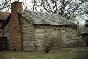
Among the new residents was George Robert Strauss, a native of South Carolina. Strauss had driven an ox team from Kansas to Utah in 1858, noting the beauty of the Cache la Poudre Valley. In 1860, Strauss returned to establish a homestead in the valley, where he initially supported himself by hunting to provide meat for the Denver market and by raising vegetables to sell to emigrants. Sometime after the flood in 1864, Strauss built a log cabin which is still standing (See Figure 2). When Strauss moved to the valley, there were only four cabins in the area, aside from the small settlement at Laporte.
In 1862, the John G. Coy family arrived in Larimer County. John Coy was born in New York of English parents and had traveled to California in 1852 to mine and ranch. Returning for his family, Coy left Missouri with an ox team heading for California. Along the way, the Coys met the Ames family, who persuaded them to spend the winter in the Cache la Poudre Valley. The Coys first stayed in the cabin of another family and shortly thereafter moved into their own small log cabin. When they obtained a homestead, they moved the cabin onto their land.
Another early settler was James B. Arthur, an Irish immigrant who crossed the plains by ox team in 1860 to placer at Gregory Gulch. Arthur quickly surmised that selling hay to the mining camps was a surer path to profit than prospecting. Arthur established a claim on the Cache la Poudre and began farming and stock raising. He obtained his first herd of cattle in Missouri and trailed them across the plains. Arthur developed a large cattle ranch from which he made a substantial fortune. He built what Watrous described as a "strong log house." Arthur sold his entire cattle holdings in 1883, foreseeing that the open range days were doomed and thereby avoiding the major losses sustained by cattlemen later in the decade. Arthur was destined to become one of Fort Collins most prominent residents, and he became involved in irrigation projects, real estate investments, and banking. He served as Fort Collins city council member, mayor, and state senator.
The new settlers brought with them a desire for organized government and, in the fall of 1860, a claim club was established with rules and regulations for residents in the Cache la Poudre and Big Thompson valleys. In 1861, Congress responded to the desire for organization by establishing the Colorado Territory. The first Territorial Legislature of Colorado created Larimer County (named in honor of the founder of Denver, William Larimer) by an Act approved 1 November 1861. The Act designated Laporte as the county seat of Larimer County, as it was then the oldest and most developed community in the county. In 1860, the Laporte Townsite Company had filed a squatter's claim to 1,280 acres of land laid out in blocks and lots. During 1862, the first post office in the county was established at Laporte.
As settlement moved westward, the mail service followed it. Regular mail service between New York and San Francisco had been established in 1848. In 1850, the service was extended to Salt Lake City. In 1861, Ben Holladay purchased from Russell, Majors and Waddell a stage service which ran from Kansas to Cherry Creek. During 1862, as continuing American Indian hostility was directed at the stage route and Denver increased in regional importance, Ben Holladay shifted his Overland Mail and Express Company route from the route along the North Platte in Wyoming to a less threatened South Platte route in Colorado. Although the exact path changed frequently, the route north from Denver followed a portion of the old Cherokee Trail and ran west of the future site of Fort Collins until the fort there was established. Laporte was named the headquarters of the Mountain Division of the trail and over a dozen stations were located in Larimer County. In redirecting the stage route through Larimer County, further attention was focused on the area and succeeding years saw increased settlement in the Cache la Poudre Valley.
Military Posts
During the early 1860s the Army, in an effort to protect the emigrant and stage trails, established a line of forts along the South Platte. As Laporte was the headquarters of the Mountain Division of the Overland stage company and a significant trading center occupying a position at the junction of the mail line from Denver and the Overland mail route, it became the center of early military activities. In July 1862, Company B of the 9th Kansas Volunteer Cavalry established a camp at Laporte to guard the Mountain Division of the Overland Stage Trail against the actions of unhappy Native Americans and also Anglo robbers who had been plaguing the line. Pioneer settlers reported that the Overland Stage Company's employees were also a source of annoyance, as "they were a drunken, carousing set...absolutely careless of the rights and feelings of the settlers." The troops were also sent to protect emigrant trains and local settlers. A military camp was established southwest of Laporte on a lowland along the Cache la Poudre on the Antoine Janis claim. The Kansas regiment was replaced by soldiers from Company B of the 1st Colorado Volunteer Cavalry in October 1862. The men built log cabins, set up tents, and erected stables.
In the spring of 1864, Lieutenant Colonel W.O. Collins, commander at Fort Laramie, sent two companies from the 11th Ohio Volunteer Cavalry under the command of Captain William H. Evans to staff the post. At this time, the location was designated Camp Collins in honor of the popular Colonel Collins. Collins was a lawyer from Ohio who had raised a regiment of volunteer cavalry at the beginning of the Civil War. Rather than being sent into the war, the regiment was ordered to protect settlers on the western frontier and it reached Fort Laramie in June 1862. After arriving in Colorado, the new detachment patrolled the stage route and escorted coaches and emigrant parties from Laporte to Virginia Dale. The soldiers occupied the cabins and tents previously erected.
Shortly after the Ohio troops arrived, a spring flood in June 1864 carried away the equipment and inundated the living quarters of the soldiers. Watrous reported that the flood submerged the camp grounds and only the roofs of the log cabins were visible above the water. Colonel Collins quickly instructed Captain Evans to search for a new location for the camp which would not be threatened by future floods. Evans directed Lieutenant James W. Hanna and a party of soldiers to locate a better site for the camp.
During his search, Lieutenant Hanna encountered local resident Joseph Mason, who suggested land near his own claim in Township 7 North, Range 69 West for the post site. Mason was a French-Canadian settler, who had come to the area after trying his hand at mining. He had purchased his claim, located opposite that of Rock Bush, from the Indian wife of a man who had been killed. Mason noted the property's location near the river, on high ground with good drainage and an excellent view of the surrounding countryside. Colonel Collins concluded that the location had "superior advantages in the way of wood, water, and grass without the danger of overflow" and that a military reservation could be established without interfering with the claims of private citizens. Collins further noted that the Arapahos in the area appeared to be friendly, but that local settlers had been frightened by other Indians and wanted to move to the fort.
On 20 August 1864, Collins issued an order appropriating the property for the military and directing the reestablishment of Camp Collins on that site, the future location of the city of Fort Collins. Collins delineated an area containing 6,169 acres, adjacent to Joseph Mason's claim (See Figure 3). Collins instructed the detachment to build quarters for two companies and officers, a temporary hospital, corrals, stables, and other necessary buildings, with a large parade ground. On 14 November 1864, President Lincoln approved the setting aside of the military reservation. The new post was occupied in October 1864 and was known as Fort Collins. Buildings on the post included company quarters, a kitchen, a guardhouse, company stables, a hospital, an orderly room, officers' quarters, laundresses' quarters, and a sutler's store.
Civilian Enterprises
To supply goods and services to the troops, a few civilians were allowed to live on the military grounds. Joseph Mason, who had been instrumental in the location of the site, was rewarded with the position of post sutler, along with Henry Chamberlin. The sutler was given a virtual monopoly on providing for the soldiers' needs, including supplying horses and selling liquor. The sutlers built a log structure at the site of present day Linden and Jefferson Streets in 1864. Mason and Chamberlin's establishment was the first mercantile building in Fort Collins and was used by both the soldiers and local settlers to obtain supplies, thereby increasing their accessibility to trade goods.
In 1865, Chamberlin sold his interest in the mercantile to Asaph Allen and the firm of Mason & Allen built a new store, known to local residents as "Old Grout." The building received its name from its building material, which was a mixture of lime or cement, sand, gravel, and small stones. Old Grout (demolished) was a one-and-a-half story front gable roofed building designed by Harris Stratton. Stratton, a Massachusetts native and former member of the Kansas Territorial Legislature, had come to Fort Collins in 1865 and later represented Larimer County in the territorial legislature. The building's design was appropriate for the fort, employing the same gabled roof, symmetrical facade, and balcony as other buildings there. The upper floor of Old Grout, which was reached via outside stairs, was used as a public meeting hall, where church services, plays, lectures, and dances were held. The first floor was used for the mercantile business, having a large shop, a storeroom, a warehouse, and living rooms toward the rear.
Another civilian enterprise on the fort was the mess house built for the accommodation of officers and run by Lewis and Elizabeth Stone. The Stones had owned and operated a hotel in Minnesota and traveled with an ox team to Denver, where they met Dr. Timothy Smith, the fort's doctor. Smith asked the Stones to move to the fort to operate the officers' boarding house. Elizabeth Stone prepared much appreciated meals for the soldiers and they fondly called her "Auntie" (See Figure 4), a nickname by which she is widely referred to today.
Auntie Stone was born in 1801 in Hartford, Connecticut, and had been married to Ezekiel Robbins, a physician. The Robbins family established a store, R. H. Robbins and Sons, in St. Louis during the fur trade era. Moving to Illinois in 1840, Ezekiel Robbins became a state representative. He died in 1852, leaving Elizabeth a substantial fortune and several small children. She raised her family, and at the age of fifty-five met and married Lewis Stone. When Lewis Stone died in 1866, Elizabeth decided to stay on and continue operating the boarding house at Fort Collins. In 1866, her niece, Elizabeth Keays brought her son to the post and started a school in one of the rooms of Auntie Stone's cabin, thus establishing the first school in Fort Collins. Auntie Stone was instrumental in the development of the town of Fort Collins, becoming associated with several significant business enterprises.
The growing settlement and development of the area around the fort was recognized by the federal government, which completed land surveys in certain portions of the county by 1864. In that year, Deputy Surveyor William Ashley reported that Township 7 North, Range 69 West had a quantity of good farming land, especially along the Cache la Poudre River. In addition, Ashley noted that the town of Laporte was well established to the north and suggested that land surrounding it should be subdivided. In the same year, Hiram Witter surveyed portions of the township and declared that the land along the Cache la Poudre was first rate farming land and was already occupied by settlers. Witter also stated that the bluffs held first rate pasture land and he had seen some good meadow land in the vicinity.
Property Types
Context
The Colorado Gold Rush, Early Settlement and the Creation of Fort Collins, 1844-1864. This context begins with the 1844 land claim of Antoine Janis and ends with the establishment of the military post, Fort Collins, in 1864.
Property Types
Property types associated with early settlement could include cabins and houses; farms and associated structures such as barns, sheds, silos, other outbuildings, fences, corrals, roads, and ditches; and stage routes and stations, along with associated structures. Property types associated with the military post could include such features as the site of the fort and the one extant building from the post, the officers' mess house known today the Auntie Stone cabin. Property types associated with Native American groups could include features such as camp sites, hunting and burial grounds, and trails.
Log Cabins/Houses. Pioneer settlers began life in the vicinity of Fort Collins with simple structures which could be quickly erected with a minimum amount of labor and materials. The earliest cabins and houses were built of logs hauled from the nearby mountains to the construction site. Foundations were of stone or dirt. The earliest buildings were of simple design and small size. In the most primitive structures, logs were left round and untrimmed. Generally, logs were flattened on two sides for ease of construction. A variety of log joints or notches were utilized, according to the builder's preferences, including full or half-dovetail notches, V notch, square notch, and saddle notch. Sod or hand-hewn wood shakes were commonly utilized for roofing material and chimneys were generally built of logs and mud or local stone. Manufactured materials, such as window glass, nails, and milled lumber had to be brought from Denver and were not readily available to earliest settlers. Windows could be added after the building was constructed and were generally of small panes of glass which was more easily transportable. Log cabins were expanded through additions as needed and few one-room cabins are extant.
The cabin which Antoine Janis built in 1859 is still standing and may represent the earliest existing dwelling in the county. The building was moved from the Janis homestead site to the Fort Collins Carnegie Library Museum grounds in Lincoln Park in 1938. The cabin is representative of the pioneer residential construction in the vicinity of Fort Collins, and is typical of the earliest homes in its simple design, use of native materials, and small size. At the same time, it is likely that the cabin reflects a number of improvements from the time of Janis's original construction in 1859. The cabin, constructed of hand-hewn native logs, has a simple gabled roof with exposed beams and wood shingle roofing, a center door of vertical half-logs, and six-light windows.
Farms, Homesteads, and Associated Structures. Watrous reported that by the early 1860s, approximately one hundred settlers lived in the Cache la Poudre Valley. Many of the farmers were soldiers who had been stationed at the fort or former miners who decided that farming would be a more successful venture. Most of the settlers established homesteads and supported themselves through farming, having taken up the choice lands along the river. The earliest agricultural activity was the cutting of native hay to sell to the mining camps. Soon, the farmers began raising vegetables, grains, and livestock. Farming and ranching were often combined. Early farm buildings were constructed with materials locally available, including logs, wood obtained from fledgling sawmills, stone, and grout. For example, Watrous reported that James B. Arthur built a "strong log house" during the 1860s.
The log house built by Robert Strauss when he established his homestead in 1864 is still standing. The one-and-a-half story cabin, about five and a half miles southeast of downtown Fort Collins on the Cache la Poudre River, has a steeply pitched, side gabled roof with wood shingles, a center door flanked by evenly spaced windows, and vertical siding in the gable ends, as well as a stone foundation. In later years, gabled wooden and stone additions were added to the structure.
John G. Coy, who established a homestead near the fort in 1862 built a house of grout, the same material used for the sutler's store at the post. Grout, a mixture of lime or cement, sand, gravel, and small stones, was used for several early buildings in Fort Collins. Although the Coy house has been demolished, the barn associated with the Coy farm still stands. The barn, constructed of stone from Masonville and vertical board siding, has a gabled roof with hay hoods. The interior of the barn was divided into storage areas for horses, potatoes, grains, and hay. When the Coy barn was built, it was the largest building in the area. Still standing are several other agricultural buildings associated with the Coy farm which were built at various stages of the farm's long history.
Stage route and stations. In 1862, Ben Holladay moved his Overland Mail and Express Company route south to what he considered a safer path in Colorado. The exact route changed frequently in response to patterns of settlement and safety concerns. Various routes of the stage have been documented, as in Petrie's map cited above.
Over a dozen stations are known to have existed in Larimer County. The Sherwood stage station house is still standing. The house was originally part of a ranch established by brothers Jesse M. and Frederick W. Sherwood in December 1860. The brothers erected a log house and raised horses, hay, and grain. For a few months during 1864, the house was a swing station for the Overland Stage Line. Swing stations, where horses but not drivers were changed, were located approximately twelve miles apart on the lines. The station on the Sherwood Ranch came into being when the existing route from Little Thompson to Laporte through Spring Canyon was abandoned in favor of a line northwest to the Sherwood Ranch and thence west along the south side of the Cache la Poudre River to Laporte. The dwelling is a one-and-a-half story, gabled building with large central chimney, which serves two fireplaces back to back. The Sherwood house has been altered by the addition of stucco over lap siding, although the original logs of the core building are visible inside on the upper story. Several additions have been made to the original structure, which is very deteriorated and open to the elements at the present time. Deteriorated outbuildings are associated with the house.
Fort Site and Buildings. The original camp site established in July 1862 has been documented, although the buildings associated with the post were destroyed by a flood in the spring of 1864 and the site was abandoned. In August 1864, a new post was established which contained company quarters, a hospital, a kitchen, a guardhouse, a sutler's store, corrals, stables, and associated buildings. The logs for the buildings were cut in the mountains by the soldiers and hauled to the fort site, where Private Harold F. Elborn, the post carpenter, supervised the construction. The doors, windows, and hardware for the buildings were transported from Denver and the sawn wood for the floors, roofs, and shingles was obtained from Obenchain's saw mill located northwest of Laporte. At Fort Collins, the officer's quarters, which were located south of the parade grounds, included three, one-and-a-half story log buildings with gabled roofs, brick chimneys, and balconies. Log barracks were constructed for the enlisted men, and log and dugout stables were excavated for the horses. The space enclosed by the buildings became the parade ground, which was located approximately between what is today's Jefferson Street and the river.
By 1901, the Denver Times was reporting that "one by one the old buildings that made up the old army fort, which was the foundation of the beautiful city, are being torn down...a few more years will remove them all unless some measure is taken to preserve them." The only building which was saved of the original post buildings was the Auntie Stone cabin. The Stone building was a one-and-a-half story log structure with a gabled roof which was built in 1864 (See Figure 5). The interior of the cabin was lined with canvas from worn out tents. The building stands on the grounds of the Fort Collins Carnegie Library Museum. The cabin was originally built on the south side of Jefferson and Linden Streets. Unlike many of the early log buildings which were quickly replaced by brick or milled wood, the cabin was moved around the city and served a number of functions before being saved as a landmark. Like the Janis cabin, it is likely that the Stone cabin underwent a number of alterations after its initial construction, including the addition of a porch, fireplace, and plastered interior walls. The Stones built a lean-to addition on the rear of lumber with a dirt roof.
Indian camp, hunting, and burial sites. The semi-nomadic lifestyle of the Native Americans wrought few changes on the landscape. Alfred A. Edwards, who arrived in Laporte in 1869 recalled "the Cache la Poudre valley had always been a favorite spot of the Indians and in the fall of the year they would congregate there and pass the winters in the shelter of the adjacent mountains. Just up the river a short distance, in Pleasant Valley, the dead bodies of former Indian chiefs, were still to be found, wrapped in skins of wild animals of the plains and securely tied up in large cottonwood trees along the river banks." Although written narratives provide some information about Indian habitation, identification of associated resources is the provenance of trained archaeologists.
Registration Requirements
Buildings representing the earliest period of settlement are significant because few examples are extant and all remaining examples could provide information about early lifestyles and construction techniques. Only two resources have been designated from this period. Individual buildings would be eligible under criterion A, for their association with the historic development of Fort Collins and their association with historic activities such as trapping, military functions, or agriculture. These buildings could also be significant under criterion C, for their architecture, as representations of the early period of construction in Larimer County and the embodiment of early construction techniques utilizing native materials. A few buildings might also be significant under criterion B, for their association with persons significant to the history of the city, if a direct and continued association between the person and the building could be established. If a building with historic integrity has been moved from its original location, it could still be eligible under criteria consideration B if it is architecturally significant or the only remaining resource associated with a significant person or event. Buildings which have been substantially altered, where little original historic fabric is discernable would not be eligible to the National Register, although they might be locally significant as markers of historic events.
Threats to Resources
The Antoine Janis cabin and the Auntie Stone cabin are well preserved and have been moved to a secure area on the museum grounds. Other cabins and early dwellings are subject to several threats, including natural deterioration, inappropriate renovation and alteration, abandonment, vandalism, and development pressures. These buildings are found primarily on the fringes of the city and their isolation makes them difficult to protect from vandalism. Buildings such as the Sherwood stage stop and the Coy barn suffer from deterioration, abandonment, and development pressures. Of the threats to this group of resources, the most critical seems to be urban development, which threatens to absorb the land occupied by the historic structures and natural deterioration which gradually erodes the historic fabric of the buildings.
|
National Register of Historic Places | |
|
None |
| Local Historic Landmarks | |
| Janis Cabin (1859) |
| Auntie Stone Cabin (1864) |
| Parts of historic district designation 200 Mathews, 1985 |
Data Gaps
Inventory of all log buildings dating from this period in the vicinity of Fort Collins
Farm buildings representative of the early settlement period
Indian camp sites and hunting and burial grounds
Identification of remaining grout buildings
Information on early women settlers in Fort Collins
1540-1858 | 1844-1866 | 1866-1877 | 1877-1900 | 1900-1919 | 1919-1941 | Introduction
Bibliography
Table 1 - Population Growth
Table 2 - List of Historic Subdivisions


Preserving the history of Fort Collins, Colorado & the Cache la Poudre region